

The Wilderness Battlefield, Fredericksburg Battlefield System
U.S. NPS
SITE
This battlefield is part of the Fredericksburg Battlefield system.
Wilderness Battlefield Exhibit Shelter:
35347 Constitution Highway,
Locust Grove, VA 22508
HISTORY

The Battle of the Wilderness was fought on May 5–7, 1864, during the American Civil War. It was the first battle of Lieutenant General Ulysses S. Grant's 1864 Virginia Overland Campaign against General Robert E. Lee and the Confederate Army of Northern Virginia. The fighting occurred in a wooded area near Locust Grove, Virginia, about 20 miles (32 km) west of Fredericksburg. Both armies suffered heavy casualties, nearly 29,000 in total, a harbinger of a war of attrition by Grant against Lee's army and, eventually, the Confederate capital, Richmond, Virginia. The battle was tactically inconclusive, as Grant disengaged and continued his offensive.


Grant attempted to move quickly through the dense underbrush of the Wilderness of Spotsylvania, but Lee launched two of his corps on parallel roads to intercept him. On the morning of May 5, the Union V Corps under Major General Gouverneur K. Warren attacked the Confederate Second Corps, commanded by Lieutenant General Richard S. Ewell, on the Orange Turnpike.
That afternoon the Third Corps, commanded by Lieutenant General A. P. Hill, encountered Brigadier General George W. Getty's division (VI Corps) and Major General Winfield S. Hancock's II Corps on the Orange Plank Road. Fighting, which ended for the evening because of darkness, was fierce but inconclusive as both sides attempted to maneuver in the dense woods.
At dawn on May 6, Hancock attacked along the Plank Road, driving Hill's Corps back in confusion, but the First Corps of Lieutenant General James Longstreet arrived in time to prevent the collapse of the Confederate right flank.

Longstreet followed up with a surprise flanking attack from an unfinished railroad bed that drove Hancock's men back, but the momentum was lost when Longstreet was wounded by his own men.


An evening attack by Brigadier General John B. Gordon against the Union right flank caused consternation at the Union headquarters, but the lines stabilized and fighting ceased.
On May 7, Grant disengaged and moved to the southeast, intending to leave the Wilderness to interpose his army between Lee and Richmond, leading to the Battle of Todd's Tavern and Battle of Spotsylvania Court House.
NPS History Page
Wikipedia
ABT History
WILDERNESS DRIVING TOUR (w/ audio)
NPS Driving Tour Stops / History - audio
NPS Driving Tour Map
In the spring of 1864 the US Army of the Potomac and Confederate Army of Northern Virginia found themselves in the same position they had been a year earlier, with one major difference. Lincoln had appointed General Ulysses S. Grant commander of all US armies. In the spring of 1864, Grant planned to increase the pressure on the Confederacy with a series of coordinated assaults across the South. In Virginia, this plan led to a series of engagements where the US Army slowly pushed the Confederates towards Richmond, known as the Overland Campaign. The Battle of the Wilderness was the first clash of the Overland Campaign and the beginning of the end of Lee's Confederate Army.
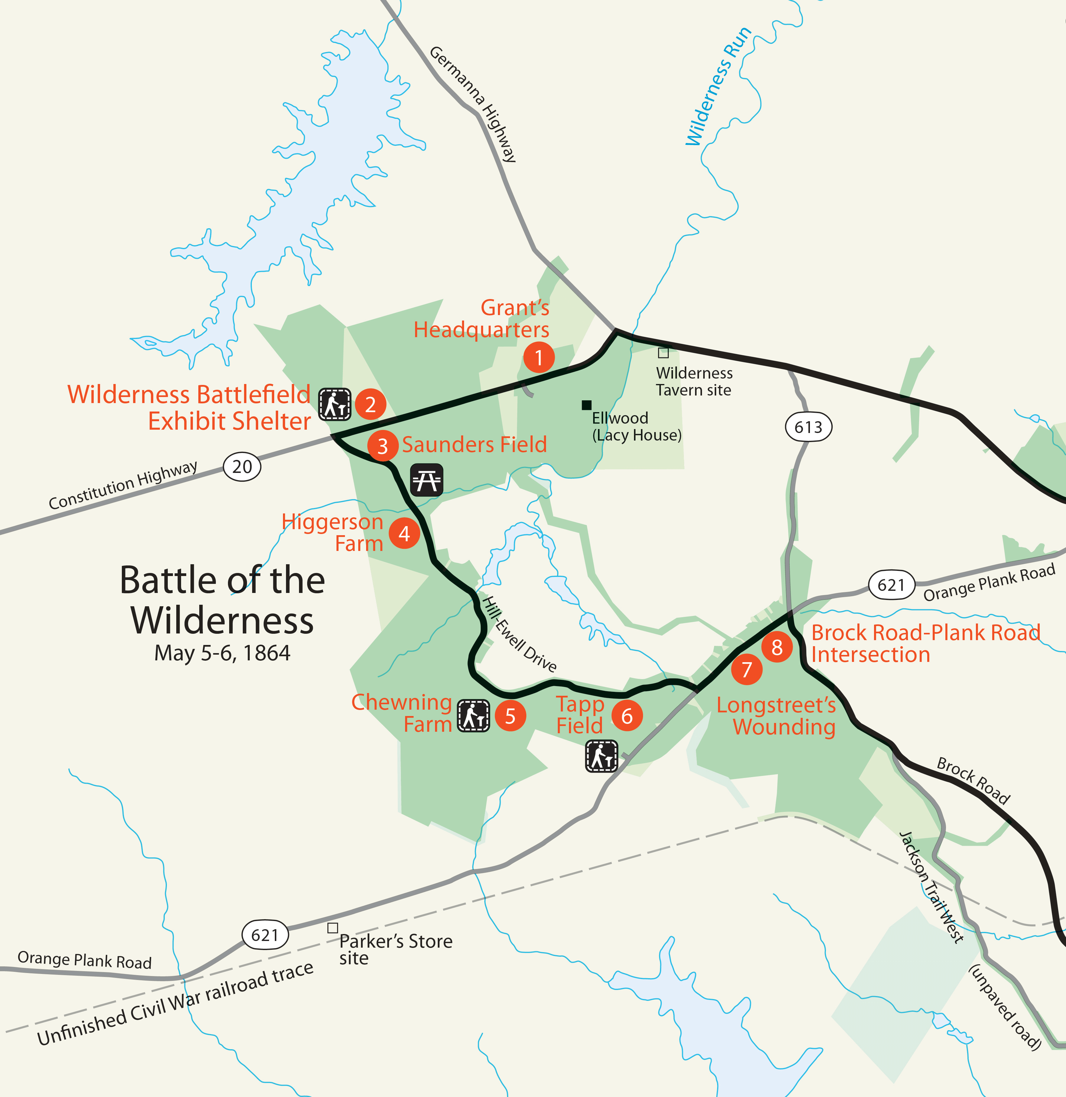
Grant's Headquarters
Difficult to see today, hidden in the woods off the Orange Turnpike, modern-day Constitution Highway, was once a small clearing on a small hill.
It was here that Ulysses S. Grant would spend much of the Battle of the Wilderness, doing his best to coral and coordinate his large force. A small tent city would have sprung up here to house all the various command and control elements of the Grant’s and Meade’s respective headquarters.
Grant brought more than just the Army of the Potomac, commanded by George Gordon Meade with him, he also brought the US 9th Corps commanded by Ambrose Burnside. Because Burnside technically outranked Meade, rather than folding the 9th Corps into the Army of the Potomac Grant planned on coordinating the two forces together himself. These attempts at coordination would take up much of his time while the moment-to-moment details were largely left up to Meade.
Wilderness Exhibit Shelter
To head directly to the Wilderness Exhibit Shelter: Drive south on Constitution Hwy (Route 20) for 1.3 miles and look for the sign for the Wilderness Battlefield Exhibit Shelter, Tour Stop #2, on the right.
Here at Tour Stop 2 you will find the Wilderness Battlefield Exhibit Shelter. Many people start their tour of the Wilderness Battlefield here. If you are doing so and would like to reach the parking area for Grant's Headquarters, Tour Stop 1, you can leave the parking lot here, turn left, and drive back. Or, you can simply listen to the audio here.
The initial clash between the US Army of the Potomac and the Confederate Army of Northern Virginia at the Battle of the Wilderness took place here, in Saunders Field. One of the few monuments on the Wilderness Battlefield, this one for the 140th New York Volunteer Infantry, is located here and memorializes the actions of May 5, 1864.
Saunders Field
Continue southwest along Constitution Hwy (Route 20) for 0.2 miles and turn left on Hill-Ewell Drive. Look out for the Tour Stop #3, Saunders Field sign in 0.1 miles and park in the pull out on your right.
Saunders’ Field was an agricultural clearing. The Wilderness has a long, if inconsistent, history of agriculture. When Europeans first began to settle the area much of the old growth forest was cleared to make way for farms, tobacco in particular. Over farming left much of the land unable to support agriculture. Some parts of the Wilderness transitioned to more industrial activities. Iron and gold mining cleared even more land before most of it was effectively abandoned.
Over time the land recovered, and the snarl of brush and trees that today is called the Wilderness began to grow in. Not all the land was left to itself. Some people stayed and others left, creating a patchwork of farms and slave plantations of every size and type, big and small, wealthy and poor. Saunders’ Field fell neatly into the mix. Owned by a New Yorker, it was farmed by its namesake the Saunders’ family. At the time of the battle, it would have been populated by the leftover stubs of corn stalks.
Higgerson Farm
Continue southeast on Hill-Ewell Drive for 0.7 miles until you see the sign for Tour Stop #4, Higgerson Farm, and park in the pull out on the right.
The Higgerson family farm rested here, just south of the Orange Turnpike. Known also as Spring Hill or Oak Hill, the farm was modestly successful, no small feat in the Wilderness, especially without enslaved labor. The 1860 census recorded Benjamin Higgerson’s land as valued at $500 and his other property at $1370. Living on the property at the time were Benjamin himself, his wife Permelia, and their children John, Jacqueline, William, and Walter, aged between 8 and 2 years old. Like many of the homes here the farmhouse was a wood frame building one and a half stories tall. Unlike most of their neighbors, at least some of the Higgerson family stayed put during the battle. Permelia went so far as to admonish the US soldiers advancing though her yard and mocked them during their retreat. Although active fighting took place on their land, the Higgersons’ home survived the war.
Chewning Farm
Continue southeast along Hill-Ewell Drive for 1 mile until you see the sign for Tour Stop #5, Chewning Farm, and park in the pull out on your right.
More prosperous than most places in the Wilderness, Mount View was the home of the Chewning family and the center of their slave plantation. Family head William Chewning’s holdings were valued at a total of $14,400 in 1860, roughly equal to $500,000. Much of that wealth was in the form of human property. William Chewning held 13 enslaved people in 1860. The rest of his wealth was in his land, his house and outbuildings, livestock, and the wheat, rye, corn, oats, tobacco, wool, potatoes, butter, hay, and honey the farm produced in various amounts. No Civil War era accounts mention the presence of the Chewnings or their enslaved laborers during the battle. They presumably fled. The home was damaged during the war but survived to be repaired and reoccupied but was destroyed by fire in 1947.
Tapp Field
Continue east along Hill-Ewell Drive for 1.2 miles until you see the sign for Tour Stop #6, Tapp Field, and park in the pull out on the right.
The Widow Tapp Farm is that last of the clearings in the Wilderness that played a major role in the battle. Catharine Tapp, the widow from which the farm draws its modern name, lived here with three of her children, Bettie, Margaret, and Harriet Tapp, and her granddaughter Eliza “Phenie” Tapp when the battle began. Both her sons, William and James, had joined the Confederate army.
In the years leading up to the war the Tapp family scratched out a hardscrabble life on land they rented from the J. Horace Lacy, owner of the nearby Ellwood Plantation and Chatham Manor in Fredericksburg. Poor and insolvent at the time of the death of Catharine’s husband, Vincent, the family isn’t known to have owned any enslaved people, instead working the land themselves to earn their living. When Lee’s army arrived on May 5, The Tapps were warned that their home was going to become a battlefield and they fled to the west. Despite the heavy fighting that would take place around their farm, their home survived, and they returned here after the battle.
Longstreet's Wounding
Continue east on Hill-Ewell Drive for 0.3 miles, then turn left onto Orange Plank Road. Drive for 0.4 miles until you see the sign for Tour Stop #7, Longstreet's Wounding, and park in the lot to your right.
One of the two roads that the Battle of the Wilderness formed along, the Orange Plank Road was a modern marvel of its time. Completed in 1853 the Orange Plank Road partially replaced the Orange Turnpike as the main route west out of Fredericksburg. The Plank Road was so called because rather than the crushed stone of the Turnpike, the Plank Road had a wood plank road surface for one lane. In some places the Plank Road used the same route as the Turnpike, but in others is diverged to make use of better ground. Just to the east of the battlefield is one of the places where the older Turnpike and newer Plank Road diverged from each other, creating the parallel roads the battle formed along.

By 1864 the road was in disrepair. Lower than expected revenue and higher-than-expected costs hurt the road company. The war hadn’t been kind either. Confederate soldiers who camped in the area over the winters pulled up the wood planks to use as firewood. Local civilians would scavenge much of what was left in the in an effort to rebuild after the war ended.
Brock Road-Plank Road Intersection
Continue east along Orange Plank Road for 0.3 miles until you see the sign for Tour Stop 8, Brock Road-Plank Road Intersection, and park in the lot to your right.
Like so many battles of the Civil War before it, and those that followed, roads and intersections dictated much of the fighting at the Wilderness. The roads leading south to Richmond had brought the US Army to the area in 1862 for the Battle of Fredericksburg. Roads and intersections at Chancellorsville made Jackson’s famous flank attack possible, while their absence from Hooker’s maps left him ignorant to their possibility. Without the many road junctions at Gettysburg there may never have been a battle there at all.
The Wilderness too had its intersections, none more important than where the Orange Plank Road and Brock Road met. On the first day of the Battle of the Wilderness, capture of the Orange Plank Road by Confederates would have spelled doom for the US Army’s efforts. The fact that the Confederates failed to capture the intersection ensured that the campaign would not end here.